“Every heavy downpour today overwhelms Kolkata’s capacity to breathe. Once a city of canals and wetlands, it now gasps beneath its own concrete.”
Biswabrata Goswami
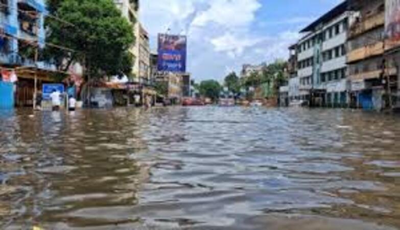
When the skies opened over Kolkata this monsoon, the city did not merely get wet—it drowned in its own forgetfulness. The rain came down in torrents, but what followed was not nature’s fury alone; it was a man-made disaster decades in the making. Streets vanished beneath fetid water, power lines sizzled in submerged lanes, and the rhythmic life of the city—its trams, bazaars, and para corners—fell eerily silent.
This was not the Kolkata that the British had engineered nor the one the Hooghly once embraced. Beneath the asphalt and apartment blocks lies a forgotten hydrological city—a labyrinth of silted canals, dead rivers, and suffocated wetlands that once kept the monsoon at bay. The tragedy today is not that Kolkata floods; it is that it no longer knows how not to.

Once a delicate balance of river, rain, and tide, the city’s hydro-geomorphic system now reels under unregulated urbanisation, ecological amnesia, and infrastructural decay. What was once a water city has turned into a water trap.
At least eleven people died in the recent deluge, many electrocuted. Experts warn this was not an isolated disaster but the outcome of decades of ecological neglect and unregulated development. Beneath the city’s dazzling skyline lies a forgotten network of rivers, canals, and marshes that once absorbed the monsoon’s excess and made life on this fragile delta possible.
A Delta Beneath the City
Kolkata sits on the lower deltaic plain of the Ganga-Brahmaputra river system—specifically on the westernmost distributary of the Ganga Delta, the Hooghly River. The land here is flat, low-lying, and built from layers of unconsolidated sediments: clay, silt, sand, and gravel deposited over millennia.
“The subsurface clay blanket, 10 to 60 metres thick, acts as an aquiclude,” explained Dr Biswajit Bera, hydro-geomorphologist at Sidho-Kanho-Birsha University. “It prevents rainwater from percolating downward, creating confined to semi-confined aquifers below.”
These aquifers, composed of fine to coarse sand, once interacted freely with ponds, canals, and marshes. Rainwater could seep, flow, and recharge groundwater naturally. Today, relentless concretisation and over-pumping have disrupted this balance. Water that once infiltrated the soil now stagnates above it, unable to drain away.
The city’s topography also contributes to the crisis: the western riverbank rises slightly higher—around nine metres—while the eastern flank dips to barely three metres near the East Kolkata Wetlands. The slightest obstruction in these natural gradients spells disaster during heavy rainfall.
The Forgotten Arteries
Long before modern drainage pipes, Kolkata’s canals were its lifelines. The Circular Canal, Tolly’s Nullah, Beleghata, Keshtopur, Boat, and Garfa canals formed an interconnected network that carried stormwater eastward toward the wetlands and ultimately to the Bay of Bengal.
The British did not conquer the swamps—they engineered them.
During the 18th and 19th centuries, East India Company engineers reshaped creeks and tidal streams into navigable waterways. Rice, fish, and timber once travelled along these channels, while monsoon floods drained away with minimal damage.
The system began to collapse when the Bidyadhari River, the main outfall channel, became defunct in the late 1920s. With its mouth silted and flow disrupted, the entire canal system was forced to carry both sewage and stormwater—a task it could not sustain.
“Once Bidyadhari died, the city lost its natural outlet,” Dr Bera noted. “The canals turned into open sewers, their flow obstructed by encroachment and landfill.”
Encroachment and the Metro’s Pillars
A walk along Tolly’s Nullah today reveals the cost of urban neglect. What was once a navigable waterway is now a fetid, garbage-filled trench. Illegal constructions crowd its banks; plastic waste chokes its bends.
“The city’s natural slope—from north to south and west to east—has been distorted by roads, embankments, and construction,” said Dr Pravat Sit, a hydro-geomorphologist at Midnapore Women’s College. “Even the Metro Railway Authority has built large pillars on the riverbed, reducing its carrying capacity and accelerating siltation.”
The result is a vicious cycle: heavy rainfall coincides with high tide in the Hooghly, the canals cannot discharge water, and low-lying areas such as Behala, Topsia, and East Kolkata remain waterlogged for days.
Colonial Lessons in Modern Flooding
Ironically, colonial engineers foresaw the problem nearly two centuries ago. Following recommendations from the Improvement Committee (1827), the British constructed the Circular Canal in 1829. Later, lockgates, sluices, and pumping stations were added to regulate tidal inflow. By 1857, steam-powered pumps were in operation to flush out stormwater.
This 19th-century hydrological system—though primitive—remained the backbone of Kolkata’s drainage until the late 20th century. Post-2000, international assistance financed canal rehabilitation and new pumping stations, but rapid urbanisation outpaced these upgrades.
Citizens frequently complain that the canals are poorly maintained. The National Green Tribunal (NGT) has repeatedly censured civic authorities for neglecting restoration and allowing illegal dumping.
A 2024 survey by Jaladarsha, a collective studying Kolkata’s waterscapes, found that long stretches of the Circular Canal (wards 13–14), the Tolly-Panchannagram link, and the Bagjola Canal were stagnant and heavily polluted. Their findings linked these blockages directly to prolonged waterlogging during last year’s monsoon cloudburst.
Wetlands: The Vanishing Kidneys
The East Kolkata Wetlands (EKW), spread across 12,500 hectares, remain one of the world’s most remarkable ecological systems. Recognised as a Ramsar Site, they naturally treat about 750 million litres of sewage daily and sustain a thriving fishery and vegetable economy.
These wetlands once served as the city’s natural flood buffer. But urban expansion—especially the growth of Salt Lake and New Town—has swallowed large sections of this spongy landscape. Illegal landfills and real-estate projects have replaced marshes with impermeable surfaces, destroying the city’s natural drainage.
“The more we fill up the wetlands,” Dr Sit warns, “the higher our waterlogging vulnerability becomes.”
When the wetlands shrink, the city loses both its sewage treatment system and its flood cushion. Water that once spread harmlessly across the marshes now surges through streets and homes.
Population Pressure and Ecological Limits
According to the 2011 Census, Kolkata’s population density stands at over 24,000 persons per square kilometre—among the highest in the world. This density exerts unbearable pressure on land, water, and waste systems. Ponds that once acted as local reservoirs have been filled up for housing or parking. Solid waste clogs every drain.
With climate change intensifying, rainfall events are becoming shorter and more violent. A century ago, the city could handle heavy rain because its wetlands and ponds provided storage. Today, with natural retention gone, even moderate storms bring gridlock and inundation.
Restoring Flow: The Way Forward
Experts are unanimous that Kolkata must abandon its piecemeal approach to flood control. Drainage cannot be treated merely as an engineering problem; it must be understood as an ecological network linking the Hooghly River, canals, ponds, and wetlands.
Dr Bera proposes a multi-pronged strategy:
l Desilting and dredging canals to restore hydraulic connectivity.
l Strengthening pumping stations and creating separate outfall channels for stormwater.
l Rejuvenating wetlands through eco-sensitive zoning and strict enforcement of the East Kolkata Wetlands Management Authority’s rules.
l Promoting urban green infrastructure—permeable pavements, rain gardens, bioswales, and rooftop harvesting.
l Community-based monitoring of canal health to prevent encroachment and waste dumping.
Urban planners also advocate mapping every surviving pond and connecting them through a “blue-green corridor” that allows water to move naturally across neighbourhoods. The idea is simple but radical: restore the city’s forgotten sponges before the next monsoon arrives.
Echoes from a Water City
Kolkata’s very identity was once aquatic. The British settled here precisely because the land’s natural waterways offered trade routes and drainage. Canals like Tolly’s Nullah and Adi Ganga carried goods from the hinterland to the port, while creeks led eastward to the Sundarbans.
“Kolkata was a water city long before it was a metropolis,” wrote an early 20th-century surveyor. “Its canals were its streets; its ponds, its lungs.”
Over time, that relationship with water eroded. Urban growth filled the ponds, walled the wetlands, and buried the creeks. What was once a breathing delta became a sealed bowl.
A Future That Flows
Climate scientists warn that extreme rainfall events like this year’s could become the new normal as global temperatures rise. If Kolkata continues to treat water as an intruder rather than an ally, it risks recurring urban paralysis.
Dr Bera argues that the answer lies not in more pumps or concrete embankments but in reviving the city’s hydro-geomorphic intelligence—the knowledge embedded in its deltaic setting. “We must rebuild Kolkata’s relationship with its water,” he says, “not through reclamation, but through restoration.”
This means re-establishing the continuum between rainwater, surface flow, and wetlands—allowing the city once again to drain the way it was designed to.
Remembering the Water Beneath
Kolkata’s tragedy is one of forgetting. The canals that once carried prosperity now carry sewage. The wetlands that once absorbed floods are being sold in square feet. Yet the memory of water endures—in the names of neighbourhoods like Ultadanga, Tangra, and Tiljala; in the rhythm of its monsoon songs; in the faint traces of vanished creeks beneath its streets.
“If Kolkata is to survive the next century of rain,” said a city planner, “it must once again learn to flow with its waters, not fight against them.”
For a city born of the delta, there can be no greater wisdom than to remember what it has forgotten: that every drop of rain needs a place to go, and every canal, pond, and wetland is part of the city’s living pulse.
Kolkata’s survival depends not on resisting its waters, but on letting them return to where they belong.